标签:
这种方式可以提高出图速度于效果,算法见http://blog.newnaw.com/?p=633,我用ArcGIS for JavaScript API来实现。具体代码为:
 1       function initDynamicMapLayer() {
 2         dojo.declare("ogc.DynamicMapLayer", esri.layers.TiledMapServiceLayer, { // create DynamicMapLayer by extending esri.layers.TiledMapServiceLayer
 3           datetime: "",
 4           constructor: function(datetime) {
 5             this.datetime = datetime;
 6             this.spatialReference = new esri.SpatialReference({
 7               wkid: 4326
 8             });
 9             this.initialExtent = new esri.geometry.Extent(-180, -90, 180, 90, this.spatialReference);
10             this.fullExtent = new esri.geometry.Extent(-180, -90, 180, 90, this.spatialReference);
11             //
12             this.tileInfo = new esri.layers.TileInfo({
13               "dpi": "90.71428571428571",
14               "format": "image/png",
15               "compressionQuality": 0,
16               "spatialReference": {
17                 "wkid": "4326"
18               },
19               "rows": 256,
20               "cols": 256,
21               "origin": {
22                 "x": -180,
23                 "y": 90
24               },
25
26               // Scales in DPI 96
27               "lods" : [
28                   {"level" : 1, "resolution" : 0.7031249999891485, "scale" : 2.958293554545656E8},
29                   {"level" : 2, "resolution" : 0.35156249999999994, "scale" : 1.479146777272828E8},
30                   {"level" : 3, "resolution" : 0.17578124999999997, "scale" : 7.39573388636414E7},
31                   {"level" : 4, "resolution" : 0.08789062500000014, "scale" : 3.69786694318207E7},
32                   {"level" : 5, "resolution" : 0.04394531250000007, "scale" : 1.848933471591035E7},
33                   {"level" : 6, "resolution" : 0.021972656250000007, "scale" : 9244667.357955175},
34                   {"level" : 7, "resolution" : 0.01098632812500002, "scale" : 4622333.678977588},
35                   {"level" : 8, "resolution" : 0.00549316406250001, "scale" : 2311166.839488794},
36                   {"level" : 9, "resolution" : 0.0027465820312500017, "scale" : 1155583.419744397},
37                   {"level" : 10, "resolution" : 0.0013732910156250009, "scale" : 577791.7098721985},
38                   {"level" : 11, "resolution" : 0.000686645507812499, "scale" : 288895.85493609926},
39                   {"level" : 12, "resolution" : 0.0003433227539062495, "scale" : 144447.92746804963},
40                   {"level" : 13, "resolution" : 0.00017166137695312503, "scale" : 72223.96373402482},
41                   {"level" : 14, "resolution" : 0.00008583068847656251, "scale" : 36111.98186701241},
42                   {"level" : 15, "resolution" : 0.000042915344238281406, "scale" : 18055.990933506204},
43                   {"level" : 16, "resolution" : 0.000021457672119140645, "scale" : 9027.995466753102},
44                   {"level" : 17, "resolution" : 0.000010728836059570307, "scale" : 4513.997733376551},
45                   {"level" : 18, "resolution" : 0.000005364418029785169, "scale" : 2256.998866688275},
46                   {"level" : 19, "resolution" : 2.68220901485e-6, "scale": 1128.499433344138},
47                   {"level" : 20, "resolution" : 1.341104507425e-6, "scale": 564.2497166720688}
48                 ]
49
50             });
51             this.loaded = true;
52             this.onLoad(this);
53           },
54
55           getTileUrl: function(level, row, col) {
56               var resolution = 0;
57               for (var i = 0; i < this.tileInfo.lods.length; i++){
58                     var lod = this.tileInfo.lods[i];
59                     if (lod.level == level){
60                         resolution = lod.resolution;
61                     }
62               }
63               var xmin, ymin, xmax, ymax;
64               xmin = -180 + resolution * 256 * col;
65               ymin = 90 - resolution * 256 * (row + 1);
66               xmax = -180 + resolution * 256 * (col + 1);
67               ymax = 90 - resolution * 256 * row;
68               var bbox=xmin+"%2C"+ymin+"%2C"+xmax+"%2C"+ymax;
69               return "http://xxx.xxx.xxx.xxx/arcgis/rest/services/WeatherServices/MapServer/export?dpi=96&transparent=true&format=png8&dynamicLayers=%5B%7B%22id%22%3A999%2C%22source%22%3A%7B%22type%22%3A%22dataLayer%22%2C%22dataSource%22%3A%7B%22type%22%3A%22raster%22%2C%22workspaceId%22%3A1%2C%22dataSourceName%22%3A%22"+this.datetime+".gif%22%7D%7D%2C%22minScale%22%3A0%2C%22maxScale%22%3A0%7D%5D&bbox="+bbox+"&bboxSR=4326&imageSR=4326&size=256%2C256&f=image";
70           }
71         });
72       }
以上基于天地图底图,效果如下:
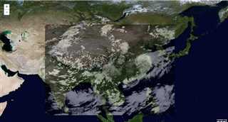
效果杠杠的,云图播放一点都不卡了。
ArcGIS for JavaScript继承TiledMapServiceLayer来实现“动态切图”
标签:
原文地址:http://www.cnblogs.com/lohcve/p/4731494.html