标签:des style blog http color io ar for sp
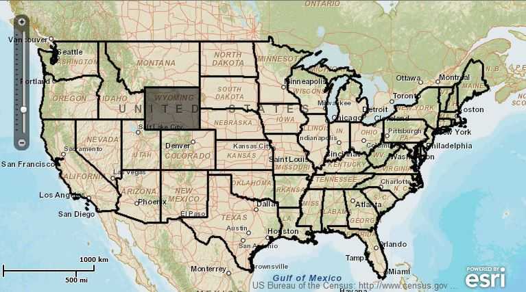
Tips:这个例子说明如何在图层中选择或反选几何对象,当点击地图时,触发mapClick事件,激活QueryTask,这里的Query中的query.geometry = event.mapPoint;利用鼠标点击的点来查找包括该选择点的Polygon,然后将查询到的几何要素添加到GraphicsLayer中并放大一个级别;同时,再次点击选择的要素时,触发unselectGraphic事件,并从GraphicsLayer中移除该要素。具体效果图及代码如下:
  1 <?xml version="1.0" encoding="utf-8"?>
  2 <s:Application xmlns:fx="http://ns.adobe.com/mxml/2009"
  3                xmlns:s="library://ns.adobe.com/flex/spark"
  4                xmlns:esri="http://www.esri.com/2008/ags"
  5                pageTitle="Select and Zoom">
  6
  7     <fx:Script>
  8         <![CDATA[
  9             import com.esri.ags.Graphic;
 10             import com.esri.ags.events.MapMouseEvent;
 11             import com.esri.ags.events.QueryEvent;
 12             import com.esri.ags.geometry.Extent;
 13             import com.esri.ags.utils.GraphicUtil;
 14
 15             import mx.collections.ArrayCollection;
 16             import mx.collections.ArrayList;
 17
 18             private var mapClickToggler:Boolean = true;
 19
 20             private function mapClickHandler(event:MapMouseEvent):void
 21             {
 22                 if (mapClickToggler)
 23                 {
 24                     query.geometry = event.mapPoint;
 25                     queryTask.execute(query);
 26                 }
 27             }
 28
 29             private function executeCompleteHandler(event:QueryEvent):void
 30             {
 31                 for each (var myGraphic:Graphic in event.featureSet.features)
 32                 {
 33                     myGraphic.symbol = mySymbol;
 34                     myGraphic.addEventListener(MouseEvent.CLICK, unselectGraphic);
 35 //                    myGraphic.addEventListener(MouseEvent.ROLL_OVER, toggleMapClick);
 36 //                    myGraphic.addEventListener(MouseEvent.ROLL_OUT, toggleMapClick);
 37                     myGraphicsLayer.add(myGraphic);
 38                 }
 39                 zoomToGraphics();
 40             }
 41
 42             private function zoomToGraphics():void
 43             {
 44                 var graphicProvider:ArrayCollection = myGraphicsLayer.graphicProvider as ArrayCollection;
 45                 var graphicsExtent:Extent = GraphicUtil.getGraphicsExtent(graphicProvider.toArray());
 46
 47                 if (graphicsExtent)
 48                 {
 49                     myMap.extent = graphicsExtent;
 50
 51                     // make sure the whole extent is visible
 52                     if (!myMap.extent.contains(graphicsExtent))
 53                     {
 54                         myMap.level--;
 55                     }
 56                 }
 57             }
 58
 59             private function unselectGraphic(event:MouseEvent):void
 60             {
 61                 myGraphicsLayer.remove(event.currentTarget as Graphic);
 62                 zoomToGraphics();
 63             }
 64
 65             private function toggleMapClick(event:MouseEvent):void
 66             {
 67                 mapClickToggler = !mapClickToggler;
 68             }
 69         ]]>
 70     </fx:Script>
 71
 72     <fx:Declarations>
 73         <esri:QueryTask id="queryTask"
 74                         executeComplete="executeCompleteHandler(event)"
 75                         url="http://sampleserver1.arcgisonline.com/ArcGIS/rest/services/Demographics/ESRI_Census_USA/MapServer/5"
 76                         useAMF="false"/>
 77         <esri:Query id="query"
 78                     outSpatialReference="{myMap.spatialReference}"
 79                     returnGeometry="true"/>
 80         <esri:SimpleFillSymbol id="mySymbol"
 81                                alpha="0.7"
 82                                color="#D3D1D1"
 83                                >
 84         </esri:SimpleFillSymbol>
 85     </fx:Declarations>
 86
 87     <s:controlBarContent>
 88         <s:RichText width="100%">
 89             This sample demonstrates how to select or deselect a graphic
 90             in a graphics layer.  This is accomplished by using a QueryTask to
 91             add features to a graphics layer, or remove graphics from the graphics
 92             layer by clicking on that graphic.  The GraphicUtil class is also used
 93             in this sample to get the extent of all the graphics in the graphics
 94             layer and adjust the map extent and scale based upon if the features
 95             are contained within the current extent.
 96             Click on a state to select or unselect it.  The map will zoom to current selection.
 97         </s:RichText>
 98     </s:controlBarContent>
 99
100     <esri:Map id="myMap" mapClick="mapClickHandler(event)">
101         <esri:extent>
102             <esri:Extent xmin="-13901000" ymin="3292000" xmax="-8812000" ymax="6154000">
103                 <esri:SpatialReference wkid="102100"/>
104             </esri:Extent>
105         </esri:extent>
106         <esri:ArcGISTiledMapServiceLayer url="http://server.arcgisonline.com/ArcGIS/rest/services/World_Street_Map/MapServer"/>
107         <esri:ArcGISDynamicMapServiceLayer url="http://sampleserver1.arcgisonline.com/ArcGIS/rest/services/Demographics/ESRI_Census_USA/MapServer" visibleLayers="{new ArrayList([5])}"/>
108         <esri:GraphicsLayer id="myGraphicsLayer"/>
109     </esri:Map>
110
111 </s:Application>
ArcGIS For Flex学习之Mapping---Select and zoom
标签:des style blog http color io ar for sp
原文地址:http://www.cnblogs.com/wicked-fly/p/4040640.html